Through primeval beech forests of Velyka Uholka
-
Difficulty
Moderate -
Distance
2,2 km -
Duration
3 h
-
Carpathian Biosphere Reserve checkpoint
,
The route starts from the checkpoint. It leads up the road; the first 300 m it passes near the homes of locals, 100 metres more – and the last buildings are left behind; the route leads up to the beech forest canopy. With each step the trail goes deeper into the forest.
-
Crossroads
,
At a distance of 200 m from the forest margin, the route branches off. Whichever of the two trails you follow, you will definitely come back to the same place. We will continue the description of the route by choosing the left direction. This route option is slightly sloping and, accordingly, easier to climb, while the right direction is steeper and more suitable for climbing down.
-
Hrebin Tract
,
300 m further, and we find ourselves in the realm of primeval beech forests. A small but very picturesque Kamianyi stream runs to the left of the trail, in the gorge. Mighty rocks of grayish limestone rise on its opposite bank. These are the eastern spurs of the rocky Hrebin ridge, which stretches from Mala Uholka. This entire slope is covered with low-growing beech 15-20 m in height, under the canopy of which the common yew (Táxus baccáta) and other species grow.
-
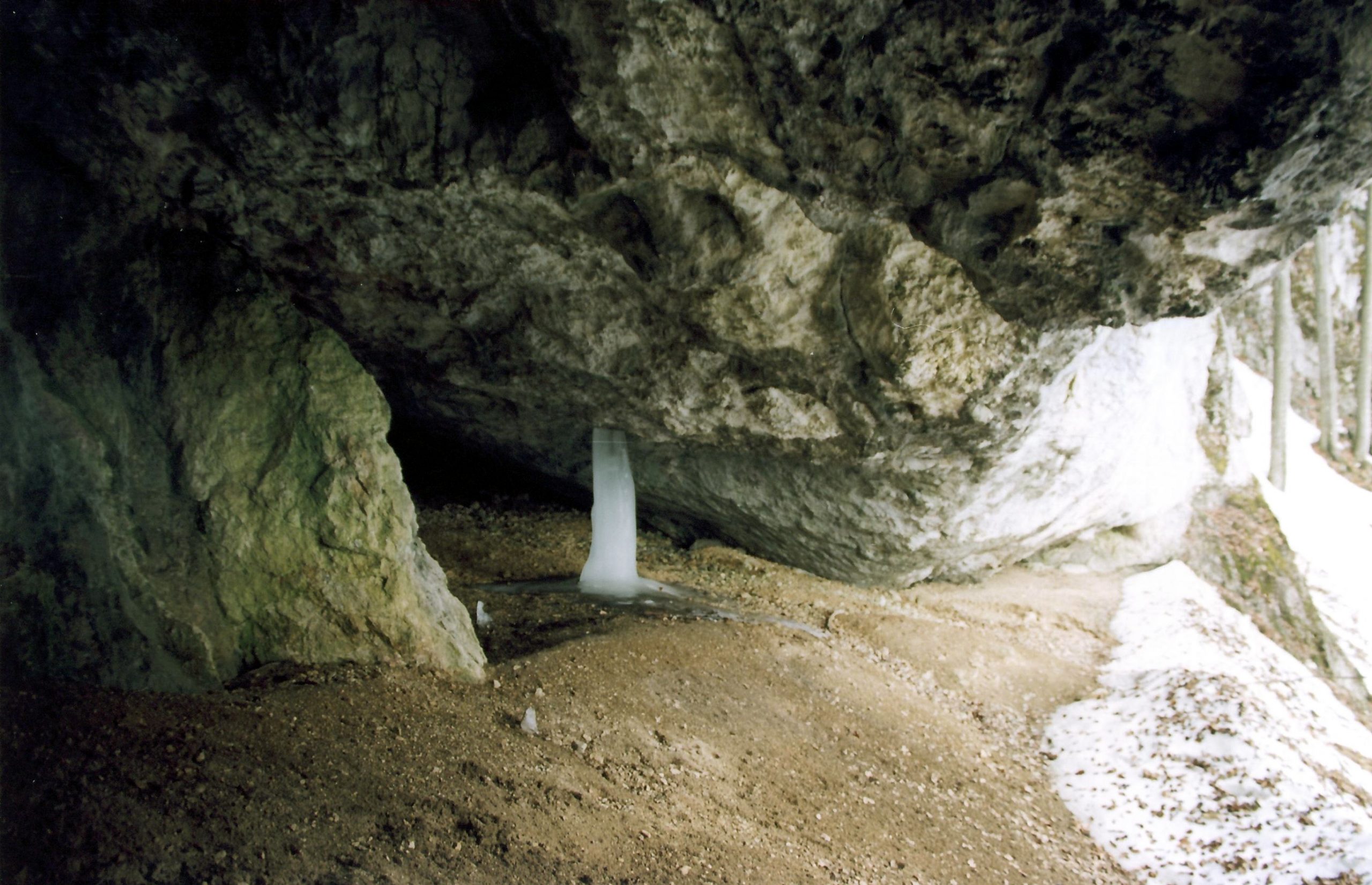
Molochnyi Kamin Cave (“Milk Stone”)

,
The road leads to the highest point of the route. This is the karst cave – Molochnyi Kamin (“Milk Stone”). Saturated CaCO3 solution oozing from limestone rocks is white and generally resembles milk.
The entrance to the cave is spacious and rectangular. The cave is two-tiered, with two passages diverging from the entrance. The total length of the cave is 92 metres and the volume is 63 m3. The cave is of interest not only due to its size and fantastic calcite inflows, resembling giant organ pipes, but also for its history. It is here that the site of ancient troglodyte people who inhabited the Carpathians in the late Paleolithic (about 20 thousand years ago) was discovered.
-
Velyka Kopytsia Tract
,
Having walked 2,700 m from the beginning of the route, we are reaching Velyka Kopytsia Tract. The rock is absolutely inaccessible on three sides – vertical walls, covered with bushes and small trees of yew and other tree species rising above the ground to a height of 70 metres. However, there is still a way to the top. On the west side, a narrow and dangerous trail leads to a small area, revealing an incredible view of the surrounding area, as if from a bird’s eye view. The top of Velyka Kopytsia, which is the name of this giant rock, is a unique natural alpine garden. Here, nature has collected dozens of relict and rare species of herbaceous and shrubby plants within meager space.
-
Crossroads
,
Having walked 4500 m, the route takes us to the already familiar crossroads. The route ends after the descent.
Deviation from the route.
Damage to natural objects.
Breeding hearths in places not designated for this purpose, smoking when passing through forests.
Felling and damage to trees plucking flowers, collecting medicinal plants.
Hunting for animals, destruction of their habitats.
Catching fish by any means.
Stay with firearms.
Territory littering, noise.
Report to the Ministry of Emergencies before you go on a hike, so that rescuers can find you quickly and in time if something happens. This requires only two steps:
-
Fill out the online form
Fill in the online form to inform the mountain search and rescue units about the planned trips to the mountains.
Online form -
Save the contacts of rescue units
Make a note in your mobile phones of the mountain search and rescue units of the area in which you are going to travel.
Contacts of divisions